
Trees
The rain is crazy. Not as windy as yesterday, when it blew our furniture off the veranda, but crazy nonetheless. I could see it coming, not just your typical clouds stretching to the earth in the distance – I could see the waves of water hitting the ground between the scattered trees, moving closer with every second. It was a race – I wanted to reach the valley, with its low profile and scattered trees, before the storm reached me. I know that in a lightening storm, you’re not supposed to seek shelter beneath a tree. But in my giant Landrover, with its 4.5 foot antennae beckoning to the sky, I don’t like being the only blip on the plains. Logical or not. (Comments from lightning experts welcome.)
And so here I am. Somewhere between cameras L05 and L06, hunkered down as the torrents of water wash over Arnold & me. The endless tubes of silicone sealant have done their job – most of me, and most of my equipment, is dry – there are only two leaks in the roof.
The sky is gray for miles – I am done for the day. It’s only 5pm! In wet season, I can normally work until 7pm, and still prep my car for camping before it’s too dark to see. Today feels like one of those cherished half-days from elementary school – not as magical as a snow day, mind you, but exciting nonetheless. Except I am trapped in my car…
So, with that, I open a beer, shake out the ants and grass clippings from my shirt, and hunker down in the front seat to wait out the rain. And to think. I’ve been thinking a lot about trees lately. Mostly what they mean for the how the carnivores are using their landscape.
See, from the radio-collaring data, we know that lions are densest in the woodlands. Living at high densities that is, not stupid. But the cameras in the woodlands don’t “see” lions very well. Out on the plains, a lone tree is a huge attractant. It’s the only shade for miles, the only blip on the horizon. All the carnivores, but expecially the musclebound, heat-stressed lions, will seek it out. In contrast, in the woodlands, even though there are more lions, the odds of them walking in front of the one of 10,000 trees that has my camera on it are…slim.
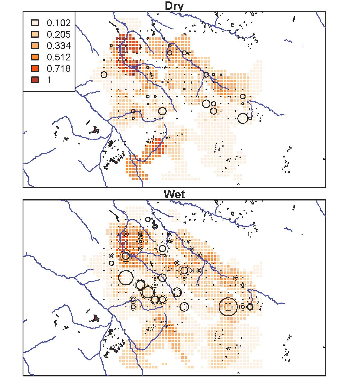
This map is one of many I’ve been making the last week or so. Here, lion densities, as calculated from radiocollar data, are the red background cells; camera traps are in circles, sized proportionally to the number of lions captured there. As you can see, the sheer number of lions captured in each camera trap doesn’t line up especially well with known lion densities. Disappointing, but perhaps unsurprising. One camera really only captures a very tiny window in front of it – not the whole 5km2 grid cell whose center it sits in. One of my goals, therefore, is to use what we know about the habitat to align the camera data with what we know about lion ranging patterns. I think the answer lies in characterizing the habitat at multiple different spatial scales – spatial scales that matter to the decision-making of a heat-stressed carnivore who sees blips on the horizon as oases of shade. And so I’m counting trees. Trees within 20 meters, 50 meters, 200 meters of the camera. One tree in a thick clump is still pretty attractive if that clump is the only thing for miles. Once I can interpret the landscape for lions, once I can match camera data with what we know to be true for lion ranging, I can be comfortable interpreting patterns for the other species. I hope.
The rain is letting up now, and it’s getting dark. Time to pack the car for camping – equipment on the roof and in the front seat. Bed in the back. And a sunset to watch with beer in hand.

Fascinating to see these data!
It might make the maps more comprehensible to all if you showed the plains-woodland border, As I recall, very roughly, the top 1/3 and the left 1/3 of the maps are wooded, the rest is open grass with very few trees.
So your big circles are almost all in open country, from cameras tied to those scarce shade-trees. And more big circles out there in the wet than dry season, presumably because during the rains those woodland-edge prides move out to the plains to hunt migratory prey.
Modeling this situation to yield pop estimates from these photo captures will indeed be a challenge!